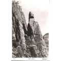
Great Gable, Cumbria - Napes Needles, rock formation - Chadwick RP postcard
- Condition : Used
- Dispatch : 2 Days
- Brand : None
- ID# : 182619707
- Quantity : 1 item
- Views : 183
- Location : United Kingdom

- Seller : justthebook (+1600)
- Barcode : None
- Start : Sun 16 Jun 2019 08:30:25 (BST)
- Close : Run Until Sold
- Remain : Run Until Sold
 for 1 item(s)
More Listings from This Seller view all


Seller's Description
- Postcard
- Picture / Image: 'Napes Needle', a rock formation on Great Gable in Cumbria - real photo type
- Publisher: Chadwick Studio, Leeds
- Postally used: no
- Stamp: n/a
- Postmark(s): n/a
- Sent to: n/a
- Notes / condition:
- Postcard
Please ask if you need any other information and I will do the best I can to answer.
------------------------------------------------
Postage and packing charge should be showing for your location (contact if not sure).
UK - PayPal, Cheque (from UK bank) or postal order
I will give a full refund if you are not fully satisfied with the postcard.
----------------------------------------------
Great Gable is a mountain lying at the very heart of the English Lake District, appearing as a pyramid from Wasdale (hence its name), but as a dome from most other directions. It is one of the most popular of the Lakeland fells, and there are many different routes to the summit. Great Gable is linked by the high pass of Windy Gap to its smaller sister hill, Green Gable, and by the lower pass of Beck Head to its western neighbour, Kirk Fell.
The Western Fells occupy a triangular sector of the Lake District, bordered by the River Cocker to the north east and Wasdale to the south east. Westwards the hills diminish toward the coastal plain of Cumberland. At the central hub of the high country are Great Gable and its satellites, while two principal ridges fan out on either flank of Ennerdale, the western fells in effect being a great horseshoe around this long wild valley.[1]
Great Gable and its lesser companion Green Gable stand at the head of Ennerdale, with the walkers' pass of Sty Head to their backs. This connects Borrowdale to Wasdale, giving Gable a footing in both valleys. The Borrowdale connection is quite tenuous, but Great Gable is ""the undisputed overlord""[1] of Wasdale in that it is paramount in almost any view up the lake. Once seen, the naming of the fell Great Gable requires no explanation.
The northern face is formed by Gable Crag, prominent in views from Haystacks and the surrounding fells. This is the longest continuous wall of crag on the fell and reaches up almost to the summit. Scree slopes fall away below to the headwaters of the River Liza, beginning their long journey down Ennerdale. There are few crags on the eastern slopes, although these fall steeply to Styhead Tarn, a feeder of the Borrowdale system. About 30 ft deep this tarn occupies a scooped hollow, dammed by boulders falling from the slopes above. It is reputed to contain trout and is a popular location for wild camping.[2] The southern flank of Great Gable falls 2,300 ft direct to Lingmell Beck, one of the main feeders of Wastwater. Right below the summit are the Westmorland Crags, and then a second tier breaks out lower down. These are Kern Knotts, Raven Crag and Great Napes, all footed by great tongues of scree. Finally on the west rough slopes fall below the rocks of White Napes to the narrow valley of Gable Beck, a tributary of Lingmell Beck.
From the north western corner of the pyramid the connecting ridge to Kirk Fell runs out across the col of Beck Head (2,050 ft). There is a small tarn in the depression, and sometimes a second after heavy rain. Both are blind, having no apparent inlet or ouflow.[2] Gable Beck runs south from Beck Head, while an unnamed tributary of the Liza flows northward. The main spine of the Western Fells continues along the north east ridge to Green Gable, dropping to Windy Gap (2,460 ft) as it rounds the end of Gable Crag. This ridge is rough and rocky, further worn by the boots of countless walkers. Stone Cove lies on the Ennerdale side while the rough gully of Aaron Slack runs down toward Styhead Tarn. The south eastern ridge provides the connection to the Southern Fells, across the pass of Sty Head. This is a major crossroads for walkers and climbers, the summit being at around 1,560 ft. On the opposite slope is Great End in the Scafells. Kern Knotts lies on this south east ridge, as does the small pool of Dry Tarn. The south western ridge gives to high level connection, dropping down Gavel Neese in the angle between Lingmell Beck and Gable Beck.
Listing Information
| Listing Type | Gallery Listing |
| Listing ID# | 182619707 |
| Start Time | Sun 16 Jun 2019 08:30:25 (BST) |
| Close Time | Run Until Sold |
| Starting Bid | Fixed Price (no bidding) |
| Item Condition | Used |
| Bids | 0 |
| Views | 183 |
| Dispatch Time | 2 Days |
| Quantity | 1 |
| Location | United Kingdom |
| Auto Extend | No |